| Historic Jewel Cave Boundary Written by Marcus Heerdt January 27, 2020 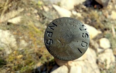 While hiking on the Hell Canyon Trail (on Black Hills National Forest land), one can spot an old boundary marker that reads: “Jewel Cave National Monument Boundary, 1936.” Jewel Cave’s boundary was once larger, and formed a perfect quadrilateral which included the southern portion of the present Hell Canyon Trail, the US Highway 16 switchbacks just west of the Historic Area, and another chunk of land on the southwestern border. | HOW TIMES SQUARE BECAME THE TIME KEEPER OF U.S. NEW YEARS Written by From The AMAC Magazine, Dec 2024 December 23, 2024 _li40.jpg) Finding Zippy: A Tale of an Elf Gone Astray Written by Adrianna Burgess December 10, 2024  Plan for the 101st Annual Gold Discovery Days Celebration July 16, 2024 National Trails Day Written by Darian Block May 31, 2024  BRIDGES OF CUSTER COUNTY March 27, 2024 |

|
||||
|
|
||||

 Current Jewel Cave Boundary Map
