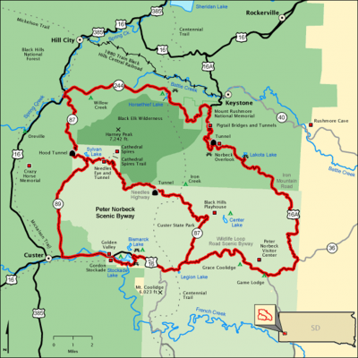
Peter Norbeck Scenic Byway
Written by Dolsee Davenport
September 4, 2018

A National Scenic Byway is a road recognized by the United States Department of Transportation for one or more of six "intrinsic qualities": archeological, cultural, historic, natural, recreational, and scenic. The program was established by Congress in 1991 to preserve and protect the nation's scenic but often less-traveled roads and promote tourism and economic development. The National Scenic Byways Program (NSBP) is administered by the Federal Highway Administration (FHWA)

Peter Norbeck Scenic Byway
This byway will lead you on a delightful adventure as it winds its way around spiraling "pig-tail" shaped bridges, through six rock tunnels, among towering granite pinnacles and over pristine, pine-clad mountains. Highlights include Mt. Rushmore, Black Elk Peak, Sylvan Lake, the Needle's Eye and Cathedral Spires rock formations.

Length: 68.0 miles
Time to Allow: Allow four hours to drive the byway or one day to experience the entire byway.

Two of the most scenic parts of the Peter Norbeck Scenic Byway include Iron Mountain Road and Needles Highway.

Iron Mountain Road: Iron Mountain Road was intended to be a work of art.  The scenic highway between Mount Rushmore National Memorial and Custer State Park was constructed in the 1930s.  Peter Norbeck planned the route that he declared “is not meant to be a super highway, to do the scenery justice you should drive no more than 20 mph and to do it full justice you should simply get out and walk.” Norbeck’s artistic expressions are shown in the three tunnels, each one framing Mount Rushmore from a different angle, and the three “pigtail bridges,” corkscrew-like structures that accommodate elevation changes while preserving the natural features. 

Length: 17 miles
Time to Allow:  All 45-60 minutes

Needles Highway: This roadway was named for the needle-like rock formations that pierce the sky along the highway.  Peter Norbeck scouted and marked the entire course of the road on foot and by horseback.  The highway tunnels through two high granite walls.  Sharp turns are in every mile.  Norbeck intended the road to be traveled slowly so that it would be relished Along your journey, you will pass the acclaimed Needles Eye, a unique rock formation created by rain, freezing, and thawing.

Length: 14 miles
Time to Allow: 45-60 minutes


HOW TIMES SQUARE BECAME THE TIME KEEPER OF U.S. NEW YEARS
Written by From The AMAC Magazine, Dec 2024
December 23, 2024


Finding Zippy: A Tale of an Elf Gone Astray
Written by Adrianna Burgess
December 10, 2024


Plan for the 101st Annual Gold Discovery Days Celebration
July 16, 2024


National Trails Day
Written by Darian Block
May 31, 2024


BRIDGES OF CUSTER COUNTY
March 27, 2024


615 Washington Street
Custer, SD 57730
605-673-2244
800-992-9818
Info@CusterSD.com


Hours:

M-F  9am-5pm                                       

Sat   Closed
Sun  Closed


           Member of
Copyright © 2024 CusterSD.com All rights reserved | Privacy Policy